I wrote this a while ago (May 2011), another multi-day vol biv trip (14-16 Feb 2011) forming part of an extended summer paragliding holiday in the mountains of New Zealand.

New Zealand beech forest
I’ve always had a thing for the mountains around the southern lakes, and this is the fourth summer I’ve come to explore them since learning to fly. While with La Nina I had high expectations, many complained about this summer’s weather. Although I did go up to two weeks without flying I still managed to get lots of memorable missions in, and I was certainly better off than I would have been had I stayed in Australia, hearing occasional reports of serious flooding adding to the general 18 months or so of rainy weather.
One such mission near the end of the trip was typical of other missions – that is, highs, lows, excited expectations tempered with patience, but in all a diverse range of experiences in a magnificent setting. Given the Easterly forecast and the fact that I’d already done a good deal of trips around Glenorchy, the plan was to push out into Fiordland, crossing the main divide at the Routeburn and heading into the Darrans (a range famous to climbers for its steep rock walls carved by glaciers), to return a couple of nights later.

On the Routeburn track passing Lake Harris

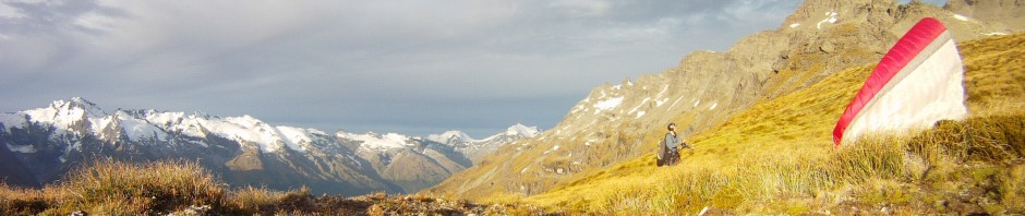
My take off spot over the Hollyford valley
As always the trip was timed precisely to suit the forecast – on the first afternoon I had a pleasant walk up the Routeburn track to Harris saddle. Cloud swirled around and gradually dissipated during my arrival in the evening. I launched perhaps slightly too early, as half way through the flight with more sun on the slopes I was able to maintain altitude and get small climbs, but there wasn’t enough lift for me to get back up to bushline or down valley towards Tutoko. Instead the gentle air allowed me a close look at the valley walls neatly clothed in beech forest, including ancient giants of trees, quite impressive and also useful as landmarks to check my progress in scratching my way back up to bushline. This did not happen however and eventually I floated down to the airstrip.
A short time later a friendly Texan, looking for a fishing spot after dropping off his rockclimbing mates, gave me a lift a couple of miles down the road to the Moraine Creek track end. He was quite impressed that I’d flown in but just about jumped out of his seat when he realised I didn’t have a motor!
With a few hours daylight remaining, I hurried up the track, just in case the sign that said 7-9 hours to Lake Adelaide was not “Bullshit”, as someone had scrawled on it, I wanted to make sure I’d have time to get myself in a good position for flying tomorrow. From my diary, dictated between heavy breaths as I climbed up the track, “at this treefall was a stinging nettle and it got me coming through on my left hand, and coming back [I got a little lost] I was aware of it so as to clear the path as I was walking over some logs I put my right foot on it and bent up against the log next to it and hit me on my right arm! I can hardly feel the one on my left arm now…!”
Upon reaching the first flatish ground beside a big beech tree I dropped my pack. Now in the hanging valley I wandered a few minutes further to a small lake where I gathered water, swearing out loud when I saw the side of the valley. Hidden until now by the beech forest, an enormous wall of rock and dripping vegetation dashed any hopes of finding a suitable launch. I’d need to find somewhere else – but that was a job for tomorrow – I wandered back to my pack, lay out my gear, ate, and slept.

Sunrise above the Moraine creek hanging valley

Cold feet is my preference over wet boots
An advantage of simplistic bivouacking is the quick start in the morning. I took my boots off to cross a large marshy flat, and a couple of hours later as the sun rose I caught up to a party which had elected to spend their night in the open, getting totally drenched by dew in the process. I know Fiordland is supposed to be wet so this didn’t surprise me. What did surprise me is that the sky remained totally blue.
I’d now seen a sloping tussock shelf up beside north facing cliffs, a launch made just for me. All I had to do was cross a terminal moraine (at the mouth of Lake Adelaide) of massive angular boulders clothed in dense west coast forest. I managed to keep my cool and came out in good time, paying a small tribute by losing my drink bottle. I did have a quick look for it but just to amuse myself really – no more instant pud!

Emerging from the bush to catch a glimpse of Lake Adelaide
I took off my boots again and let the tussock, alpine plants, and cool trickles of water massage my feet for a while. Then around midday I dropped the pack at launch, waited for the odd scenic plane flight to buzz past, then kitted out in warm clothes and the usual electronics and launched.
Certainly one of the more awe inspiring places to fly. Immediately after leaving my rounded tussocky knob I found myself 800 metres above the hanging valley I’d been that same morning, myself just a speck on the massive faces I’d been looking at the night before. Puffs of hot air rose up the cliff faces, and I patiently worked the lift back and forth, looking for a thermal between the take off spot and the drop off into the main Hollyford valley.

A video grab from the flight over Moraine creek
An hour later and still waiting to break through the inversion and get up into the tops I began to get to know each imperfection and feature in this particular Fiordland cliff. While the scenery was superb I was a little rattled with the prolonged constant concentration required when flying so close to such dramatic terrain. It was definitely a stable day – hot air rises only by brute force as the atmosphere suppresses any thermals, which also explains why the sky remained blue. I found out later that a friend was flying the local site in Wanaka on the same day, with the same experience – the frustration at not being able to break away from launch height! The infuriating thing is that you can never know if or when heating will become sufficient to break through, and the only thing you can do is hang in there and keep trying. I could remind myself that I was in an amazing area I’d never previously been, and I should soak up the views and remember them. But meanwhile my Wanaka friend, having cashed in all kinds of brownie points to get the day off work, was ironically confined to his workplace (he is a tandem pilot) and not able to venture into the backcountry!
After the second hour of scratching I had an excuse to relieve my anxious nerves – the sun was starting to swing off the face! I flew out into the main valley and soared up a less impressive but more welcoming forested slope back to regain launch height. Then crossing the Hollyford with views all the way out to the ocean, I returned to the same western facing slopes I’d flown less than 24 hours ago!
Thus continued my longest flight of the season. I worked and worked, up and down the valley. Finally, on the most promising looking beech spur, I managed a few turns in lift – what is this, a thermal – indeed! Finally my patience had paid off. For the first time I rose above bushline, some flat open ground by a tarn within a short glide – for a fleeting moment – I hesitated, and sunk down below bushline again. That meek altitude gain of one hundred metres (probably less) was to be my only thermal of the day. I scratched for another hour but as the sun lowered the lift weakened and I sunk lower and lower before finally, defeated, I landed in the very bottom of the Hollyford at Gunn’s camp, which was now in shade. Things could be far worse however. After a hot shower some university students took pity in my modest meal of noodles and I gratefully polished off second dinner, before a comfortable sleep in a bed of all places!

Late stages of my flight from Moraine ck and over the Hollyford
Early the next morning I rose and began the steep climb up Dead Man’s track, enjoying the climb to Harris saddle in the shade. Continuing up Conical hill the air was still, the sky clear, and walkers plentiful – I enlisted a couple to help me launch. The spot I found was tight – bluffs a few steps below – so half a dozen people holding up my canopy made my job a lot easier. It was maybe the third or fourth attempt when after taking a few quick steps I felt supremely confident with the feeling of pressure in my wing and continued the dash into the void. Again flying was perhaps unnecessary but it certainly was a nice way to cross over Lake Harris – I landed half way up the slopes on the other side and tramped around to more substantial slopes facing the morning sun.

Looking west over Lake Harris to Conical hill
Today another friend was flying a few valleys away from me. I found out later that his flight was somewhat similar to mine the previous day – he’d stayed up for several hours but kept bashing his head against a lift inhibiting inversion. Well today my luck was better than that – I launched above it!
I flew up the valley past a startled chamois and then found a climb and wound my way up past alpine scree fields and lakes of various blues and greens. Distinct in the featureless scree slope a tramper crawled out from under a yellow tarpaulin – I yelled out hello and he quickly stuck his head back under the tarp to arouse his mate! Soon they were far below and I was playing with the cloud forming a few hundred metres above the top of Xenicus peak. I was in a jubilant mood, clearly brought on by the stunning scenery, but also no doubt enhanced by the contrast of my flying fortune to that of the previous day!

Climbing up over Xenicus (Routeburn north branch)

Toying with the clouds, looking north to Somnus
After allowing adequate time to absorb the experience, toying with the cloud on my perch above the main divide, finally I opted to head onward. I glided around Momus and over Bridal falls, eyeing out the terrain as this is a climb on the to-do list for a non-flying day. The glide was just a little further than I anticipated as the terrain kept opening up and by the time I reached sun facing slopes I was down below the inversion again. Soon I landed in the Rockburn valley floor.
Despite having just experienced a highlight of the summer with that flight, it is always disappointing to land before the peak thermal time of the day! It was barely 2pm so I still had time to climb up and fly again! Luckily I was fit after a season of tramping and vol biv – after chocolate for lunch it was just under an hour to bushline. Climbing over a shattered slope of lichen covered rocks I dictated into my diary, “I quite enjoyed pulling my way up through mossy branches… I better watch myself – maybe I’m going crazy – because that was a bush bash!”
Late in the afternoon, still in full sun and happy to feel hot gusts up the slope I spent the extra time to get to a tussocked slope away from the boulders. Then I pulled up the wing and sailed my way up Mt Nox, a great vantage point for viewing Lake Unknown, normally high and hidden by surrounding mountains. The evening light was gorgeous and with food reserves running low I was happy to be within glide of civilisation.

Climbing the flanks of Mt Nox, overlooking Lake Unknown

Looking toward my eventual landing in the Dart valley from Mt Nox
I wonder how I can still be surprised in this sport, but I did think that when I reached the massive west facing hulk of Earnslaw and Turret head I’d get an easy climb and subsequently landing in the front paddock would be a shoe in. However I suppose I slipped below that inversion again, and once again landed a little before I’d hoped. But it didn’t matter – I was soon picked up by some climbers returning from Chinaman’s bluff, and being kindred spirits with a love of the backcountry, they appreciated my story.
