Hike and fly is a challenging and rewarding way to experience the outdoors. The well earned flight brings the hike to life, the sum being greater than the parts. I also believe that it’s a great way to improve your flying judgement with a steep learning curve – the confident pilot may go alone but also consider making it a social outing and pooling your experience. Here is some commentary and resources for ten flights I’m familiar with to whet the appetite and get you thinking…
Flying past Hedin Peak, before turning around to check out the glaciers
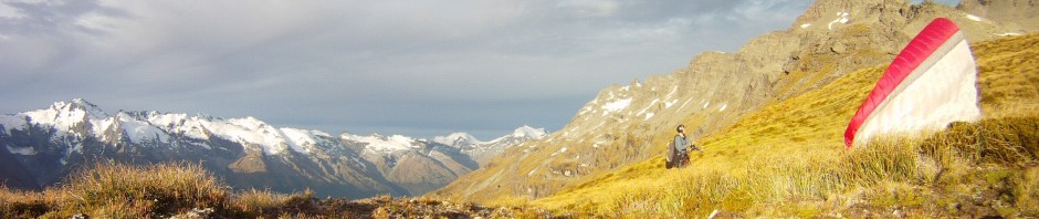
1 Roy’s peak, Wanaka

Returning to Roys peak, Wanaka after a day in the hills
The most accessible hike and fly, well used by a cross section of the flying community, one of the best views, tussock slopes ideal for launching and wide open valleys. Recently proven as a brilliant cross country starting point with the triangle record and highest scoring flights in New Zealand.
My preferred route is to walk up the waterfall route which starts a couple of kilometers closer to Wanaka than the very popular zig zag route (see the DOC link). Roy’s peak is a great “low risk” hike and fly, in the morning sun you feel the thermals as you walk up and if you get it wrong there are face landing opportunities everywhere. You can make the glide to Treble Cone lower than you think, and if you don’t make it you’ll find yourself at the landing paddock of the most popular cross country site in the country just as they start mobilizing to car pool to launch.
Access: Ten minute drive on sealed public road from Wanaka. Walking track open to public.
Hike: From 45 minutes to three hours depending on where you want to launch. It gets hot so start early.
Launch: Some prickles lower down but mostly good tussock slopes.
Landing: Slope landings abound, acreage lots and farms below, wide open Matukituki valley to the west.
Weather: Exposed to various winds, talk to the Wanaka locals. Generally dry central Otago (check the Southern Lakes forecast or if you like forecasts check this.

Roys peak waterfall route (can continue to summit if desired)
2 Shark’s tooth, Mt Aspiring national park

View into West Matukituki valley, Raspberry ck centre and Sharks tooth slopes to left
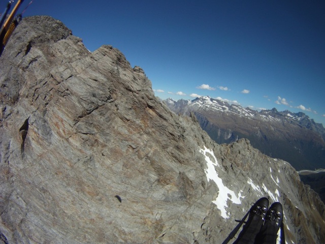
Deep in the mountains, yet only a short walk from the (Raspberry creek) car park, Shark’s tooth is a well defined steep tussock spur with launch options the whole way up. Just across the valley is a razor sharp spur offering a thrilling ride over the picturesque Mt Roy glacier (a great half day walk, on a windy day watch the waterfalls being blown uphill) and deep into the mountains of the national park including views of the Popes nose and Coxcombe ridge of Mt Aspiring. You can fly west towards Cascade saddle or east back to Wanaka and beyond.
Access: Get permission from the farmer (normally no problem), ask the facebook group (see below). About a one hour drive from Wanaka, over half is gravel including fords (creek crossings) but generally OK for two wheel drive. Raspberry creek car park is the main gateway to Aspiring national park – get track transport or hitchhike.
Hike: Cross the paddock slightly east of the car park and start walking up the spur. One to three hours depending on where you want to launch.
Launch: Tussock slopes but you need to look for somewhere not too steep to lay out your glider.
Landing: Wide open Matukituki valley in all directions. Some slope landings possible but it’s steep.
Weather: Exposed to norwest if it’s dominant but also located in the lee of the Matukituki valley wind, be aware of that if flying east.See cross country flights from Sharks tooth (more recent xcontest).

Sharks tooth, the tussock spur south of Raspberry creek carpark
3 Sugarloaf saddle, Routeburn track

“Gradient lake” and Mt Earnslaw from above Sugarloaf saddle
The most accessible hike and fly in the Glenorchy region, much of the traffic in this mountainous cul de sac is headed for the Routeburn track. Take the “Not the Routeburn track” detour to Sugarloaf saddle and you’ll find yourself at possibly the next site to break the New Zealand open distance record (ask Bryan Moore?). The best stuff is nearby though, mountains capped in ice and clothed in native bush set upon beautiful river deltas and flats in the glacier carved valleys. Be sure to know the backcountry very well (see Moirs guide) if you plan to venture that way, otherwise enjoy the flight back to Glenorchy via Mt Alfred (probably the best viewpoint in the country), and the craggy Richardson range – there’s a large range of vegetation and scenery changes here nestled up against the main divide.
Access: An hour and a half drive from Queenstown, mostly sealed and OK for two wheel drive. In season plenty of daily traffic (to track in morning) – get track transport or hitchhike.
Hike: Follow signs to Sugarloaf saddle after ten minutes on the Routeburn track (see DOC link). Allow three hours, mostly under beech forest. The saddle is flat ish and boggy, climb a hundred metres higher up the ridge.
Launch: Tussock slopes but a little uneven, would need care with a tandem. Look for the gradient lake!
Landing: Limited slope landing options available above bush line. A long walk back from river flats in the Rock burn. River flats within twenty minutes walk either side of Routeburn car park.
Weather: Exposed to norwest intruding down the Routeburn – possible convergence over car park. Generally exposed to wind and moist air incursions being near the divide. On nice days a light southerly in the main valley (Glenorchy) but easily influenced by synoptic (meteo) wind.

Sugarloaf saddle track above the Routeburn valley
4 Gertrude saddle, Fiordland

Looking into Milford sound from Gertrude saddle
Certainly one of the more committing places to fly a paraglider (you’ll see what I mean on the drive in on the Milford road). It’s a nice tussock launch but you are hemmed in on all sides by glacier carved Fiordland cliffs with nothing but west coast jungle between you and the frothing white caps of the sea breeze on Milford sound. Access is via a formed track, albeit covered by avalanche debris as late as December. If you manage to get away you get to deal with the sea breeze howling over the Homer pass (I’ve experienced convergence over the car park), and if you stay high enough to negotiate the forested section to the main divide your next challenge is to pick the sea breeze convergence from the Hollyford valley and Te Anau and get yourself into the Routeburn valley. Spectacular and thrilling.
Access: Two hours from Te Anau, sealed public road to Milford, exit before tunnel. Tourist traffic but hitchhiking a bit slow. Fly in from Glenorchy instead??
Hike: Marked track up the valley and climbing rock slabs (bolted grab wires for exposed sections) besides the creek and lake. Amazing walk but subject to avalanches so season is late summer. See the DOC link.
Launch: Tussock slopes on the pass with cliffs below so you better be comfortable ground handling.
Landing: Desperate landings immediately below, ask Micheal Karnik about the jungle bash out. I guess you could land on launch in perfect conditions, but then what. Landings at car park if you can get down. Otherwise it’s best not to think about it.
Weather: Sea breeze concentrated into deep fiords and U shaped valleys. Maritime air mass can make thermals and lift less dominant, despite imposing cliff faces everywhere you look.

Gertrude saddle near Homer tunnel on the Milford road
5 Brewster hut, Haast pass

Brewster hut and the NE facing house thermal spur
A great walk with a nice hut to spend the night at if you don’t want to be in a hurry – the house (hut) thermal on the razor sharp ridge starts working early. The problem with this site is that this narrow passage through high mountains and west coast bush is so unique – the road is the only pass over the main divide on the southern end of the country, and the wind knows this! Down below in the tight forested valley with limited small river flats, afternoon winds can be very strong from either direction with little indication of this up at the hut – beware. The dream line from here is to fly to Mt Cook – but given it’s completely remote, wild and untouched, you better know exactly where you are going and have a good back up plan! A nice alternative is to fly back along the highway towards Wanaka.

Above Brewster hut (click for panoramio link)
Access: Hour and a half from Wanaka, sealed public road to west coast, exit before Haast pass at Fantail falls walk.
Hike: Ignore tourist cairn building projects and cross rocky riverbed to find marked track (see DOC link). Great steep three hour walk to the hut, rising above the beech forest for the final knife like ridge to the summit. Get a DOC backcountry hut pass and stay the night.
Launch: Easy – relatively flat tussock with plenty of space to lay out your glider before taking the leap off steep north faces which start working early.
Landing: Problematic, fairly tight rocky river flats in a confined wind exposed valley. Fine in good conditions. Good top landing at the hut but the house thermal complicates things somewhat!
Weather: Pay special attention to the wind forecast and sea breeze potential, particularly if flying in thermic conditions.
See cross country flights from Brewster hut.

Mt Brewster near the Haast pass
6 Sealy tarns, Mt Cook national park
An iconic place to fly with the raw and stark beauty of the highest mountain in the Southern Alps right in front of you. Also one of the busiest airspaces in the country – beware, it’s an MBZ (the good aviation practice guides are a great resource) so you must use an airband radio.

Mt Cook (Southern Alps) MBZ (may be out of date!)
Get in touch with a local pilot (try Wanaka backpackers) with the rating and team up to tackle the strong thermals of this arid region – so close to the we(s)t coast, yet so far. With the easterly aspect it makes a good starting point for cross country flights to the south, but the coveted prize is to fly around the enormous Mt Cook massif – the Caroline face is a two kilometre high wall of ice and unstable rock – and there’s no alpine cow pastures or Seilbahn téléphérique serviced mountain refuges here!
Access: Five minute drive from Mt Cook township, popular tourist track.
Hike: Up to two hours on heavily trafficked track with patches of bush to shelter from the hot sun. See DOC link.
Launch: Tussock and a small shelf with tarns behind, not much room but OK.
Landing: No obvious face landing options, but plenty of space to land in the wide valley below – unless you head north towards Mt Cook, where it’s all glacial debris.
Weather: Watch for norwest spilling over the divide. Otherwise the mountains pull in a strong southerly valley breeze. Strong thermic conditions.
See cross country flights from Mt Cook

Sealy tarns above Mt Cook village
7 Mt Peel, Canterbury plains
A great diversion if you’re on the way between Southern lakes and Christchurch. A popular track leads from the car park at the base though lovely native bush up to the tussock ridge from Little Mt Peel. A gentle sea breeze from the Canterbury plains fans the slopes as you take in the views of the dry golden brown hills in the rain shadow of the Southern Alps in the distance behind. After a short and sweet out and return, land at the paddock next to the car park and continue on your way.
Access: Three hours from Christchurch, near Geraldine. DOC marked track. (DOC info brochure)
Hike: Nice two to three hour climb mostly under native bush.
Launch: Tussock slopes, a little steep but OK.
Landing: In a comfortably sized paddock next to the car park.
Weather: Sea breeze influence from the plains which are typically covered in a milky inversion. Watch for norwest.

(Little) Mt Peel track near Geraldine
8 Mt Bruce, Arthur’s pass

Top landing on Mt Bruce above the Waimakariri river
Probably best in winter, this peak offers views across the Waimakariri valley to peaks of the main divide such as Mt Rolleston and Avalanche peak over Arthur’s pass. I have landed here in summer, and thanks to a huge slope of sun baked rocks and scree to the east I managed to get away, only to get washed down to the expansive Waimakariri river flats as the valley breeze claimed me. The better bet would have been to make the long crossing to Klondyke corner, a forested spur by the Arthur’s pass road which scoops up the valley breeze and leaves you with the choice of two mountain ranges on either side of the narrow mountain road, and a lot of wilderness. It’s on my list to cross the divide here, as my friend Hamish did some years ago, making a impromptu bivouac with a French pilot as they landed high to escape the sea breeze.
Access: Three hours from Christchurch on the Arthur’s pass public road, stop before crossing the Waimakariri.
Hike: Follow the track past Bealey hut (DOC link) then follow slopes to the summit.
Launch: Tussock slopes (covered in snow?), no dramas.
Landing: Slope landing or the wide valley below.
Weather: On good days a strong valley breeze will follow the Waimakariri to the mountains. Strong thermic conditions on arid rocky slopes. Pay attention to the weather forecast for Canterbury high country.

Mt Bruce, south of Arthurs pass
9 Mt Fox, West Coast

Coastal strip near Fox glacier, West Coast
I’ve only done it once, when after some trying late season vol biv a promising forecast lured me out to the west coast. Mt Fox is next to the famous glacier of the same name and due to the tourist flights is the busiest uncontrolled airspace in the Southern hemisphere! Being in the MBZ (see Mt Cook entry above) you need an air band radio but on consultation with the local pilots I was excused given I flew before 7am. As if finding the track through west coast jungle wasn’t enough of a challenge, try doing it in the dark! Let’s just say it was a well earned sled ride down to the vibrant green coastal strip… I celebrated with an evening hike and fly of Mt Brewster (see above) the same evening!
Access: Ten minutes drive from Fox township on the west coast highway.
Hike: A DOC track (see DOC link) in an unknown state, quite possibly overgrown.
Launch: Tussock slopes, usually dripping wet, difficult to find a launch possibility with rolling terrain and nearby bush.
Landing: Easy, acres of green grassy fields on the coastal strip.
Weather: Raining or about to rain, always wet and clouds up at the drop of a hat.

Mt Fox above the glacier and township of the same name
10 Mt Fyffe, Kaikoura

Kaikoura peninsula from slopes of Mt Fyffe (winter)
If the endless westerly winds in the south are getting you down, it might be time for a car hire $1 relocation road trip to the North Island – Mt Fyffe is the perfect stop on the way. Kaikoura is a tranquil seaside town known for its whale watching but also boasts two mountain ranges on its back doorstep. A spacious track leads through regenerating native bush past a charming hut and to the summit just above bush line jutting out from the Seaward Kaikouras. I arrived late evening to find gentle lift coming off the rocky western slopes, enough for a few extra wingovers as I followed the ridge down to the paddock next to the car.
Access: Less than half an hour from Kaikoura on sealed country roads.
Hike: Around three hours on an old 4wd track following the ridge through native bush.
Launch: Reasonable launches for most directions on summit and other options along ridge.
Landing: Comfortably sized paddock next to the car park.
Weather: I’m not a local but it often seems to be somewhat sheltered by the mountains, a tranquil setting fitting of Kaikoura.

Mt Fyffe just west of Kaikoura
Put on your boots and go
To start with I’d suggest Roys peak, Shark’s Tooth, Mt Bruce, Mt Fyffe, and Mt Peel, but it all depends what you’re comfortable with and the weather on the day – you need to be confident enough to make your own judgements. This page is not necessarily up to date or authoritative and is definitely not comprehensive – there are dozens of other options. Have a look at my tips on vol biv, get in touch with the Fly Hike NZ facebook page, check the resources of my 2015 Red Bull X-Alps supporter Louis, and if you want a helping hand get in touch with Paraventures in Queenstown / Wanaka or my former instructor.
