My 2020 trip to New Zealand was somewhat disastrous, after saving my new sub three kilogram Ozone Zeolite just for this (flying around an old rag in Oz), I brought the wrong wing by mistake. It certainly made a difference for the first four day trip, and the rest of the trip was salvaged by the generous loan of a wings for the trip (thank you Brooke, also Josh for the tandem). When my girlfriend left the weather took a turn for the worse and after a few windy flights I was rained out. But all in all a lot of country covered, still with some new places mixed in. Notable this year was the snow stained pink by Australian dust and ash, the horrific bushfires helping accellerate glacial retreat.

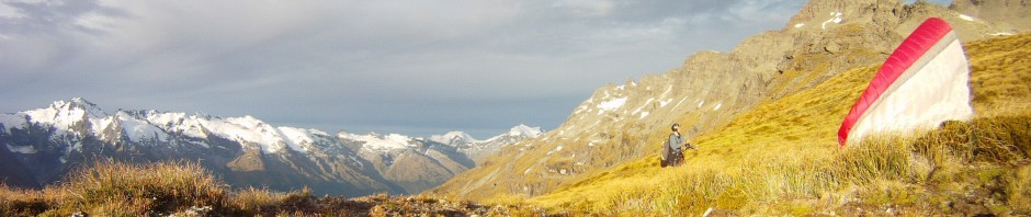
Mt Aspiring (distant right) from the head of the Joe. 19 Feb 2020
Racing from the airport straight up Coronet peak, after a busy few days in Australia, I began a four day vol biv. It was a struggle just like the old times, with too much hike and not enough fly. The best way I could explain my urgency to get out there to my girlfriend was that we hadn’t seen a weather forecast this good for some years – yet I was struggling to get anywhere. Compounding this was problems with the ultra lightweight ex-2019 xalps harness which I had a lot of difficulty adjusting. On the first day my objective was to fly to a good starting point, but I sunk down over the back of Coronet peak and spent the afternoon sweating in the sun. Hopes of somewhere in the Lindis changed to Roy’s peak, where at least I’d be able to resupply. I’d brought all my food from Australia to save time so you could characterise my diet as “crackers and cheese, without the cheese”. In the end I found myself soaring the shadows in the evening sun with my starting point only a glide away.


At least I’d managed to land in a good spot – near a flowing stream, a short walk from east facing tussock slopes. The next day I hiked up, flew, got a thermal, and landed to adjust my harness. Flew, and landed again after getting a minor thrashing, again to make adjustments. Flew and had a terrible glide, landing for a really short flight where I couldn’t even clear a small col, then the infamous launch (after losing my jacket on the ridge, and having to go back for it).
I couldn’t bear to fly past running water so landed for a drink, then flew again but after escaping the high valley I sank all the way to the valley floor, after a desperate attempt at soaring the other side meant I was too late to hitchhike back to Queenstown. I hiked up again for a final evening glide to cross an overgrown gorge, had a welcome wash in the shade, and pitched the tent in the evening.

Paper diary entries
A long walk the following morning and I first saw the sun when on the summit of Church peak. I was still hoping for a big flight. Launching this time with my leg tangled, I had to land, in a thermal, to fix it. When I took off again I sunk out, and eventually landed in the valley. Then I raced up the hill without packing up properly, conscious of time. There was a rushed detour through heavy scrub to top up on water, and a few goes at launching as the clouds started to influence cycles coming up the easterly face. A short flight to the bottom and I decided to try the other side of the mountain. This time I climbed straight up to hill height, went on glide to the mountain and got crushed in heavy sink all the way to the valley floor again. Suffering all the way up to the tops on foot, a cold wind chilled me as I launched for the last flight of the day – this time at least managing to soar and cross a small valley to a good campsite overlooking the Matukituki valley.

Kea from my tent (near Treble cone)
It was a tough decision not to glide towards Wanaka, but given the limited traffic late in the evening I voted against my belly. As much as I wanted a reprieve, I didn’t want to hike up the hill again. The morning looked good but there was an inversion. I lost height, waited, flew again and thermalled up high, patiently, before gliding all the way down, virtually to the valley floor. I hiked up again and looked for a launch amongst the scrub. The only one I could find was the grassy patch growing on top of a boulder, which I’d been resting under in the shade. Another paraglider flew past and saw me, thinking I was a lost tourist. Neither of us knew it then but I’d be flying the same wing in just a few days – it was Brooke.
The launch worked and I went left around the corner to work my way up north facing cliffs. Into the West Matukituki and I saw other pilots circling together – Stefano and Kinga, who had been having some similar frustrations I later learned. But today they were flying efficiently and left me to discover for myself that the wind wouldn’t let me get anywhere near Cascade saddle, where my girlfriend and her brother (Natalia and Jack) were hiking that day on the Rees Dart track. The longest flight of the four day trip by far, I nearly made it back to Wanaka. On my final glide into Glendhu bay I finally realised that I was underneath the Z-Alps. This wing does not even pass porosity checks! I told my sorry story to a Christchurch couple as I hitchhiked back to Wanaka, then promptly left my valuables bag (electronics, chargers, passport, etc) in their car.
See the full Shotover videos in three parts (day 1-2, day 3-4) at patreon
Early the next morning I posted on facebook asking if anyone had a spare wing they could lend me. I fell back asleep and awoke to multiple offers. Later that day I took Brooke’s as-new U-Turn EN-C prototype for a flight, Roy’s peak now being a popular hike and fly choice given the closure of the road up Treble Cone. Today I had no ambitions, thinking I’d salvaged my situation satisfactorily to be able to fly at all, yet I still flew an order of magnitude further than the combined trip so far.

Roy’s peak is getting popular
Having only a single flight for the first time since arriving, I made a big circuit roughly following Louis’ 197km triangle route, but cutting the corners. The wind in the Dart valley would have made it difficult so I snuck down the Rees valley instead, recalling a flight years ago where I soared the norwester and then noticed it turning direction up the Rees to give me tailwind. It was most enjoyable efficiently selecting a spur to soar and taking it until I connected with thermals again, something I haven’t always managed to do in this valley.
Ayvri 3D track: Roys Richardson Wanaka loop
Full video at patreon
As I approached the northern end of the Richardson range I had a headwind to contend with. Watch the video of me having an inflight conversation with Cleft peak. From there I crossed into the head of the Dart valley which I noticed was nicely protected from the wind. I took advantage of this having a relaxing glide past glaciers before having to contend with bumpy thermals again. Then I glided into the Matukituki to reach ground speeds of over 90km/h. I glanced over at Liverpool hut, thinking it was possible that Jack and Natalia might be there, but in any case they weren’t and I had no hope of reaching there. Instead I reached my favourite spur beside Rob Roy glacier with just enough height, and continued soaring most of the way back to Wanaka.
Josh put me up for the night, all very civilised this paragliding without an off-grid power solution, etc etc – no news about my day bag yet. In the morning Brooke joined us for Lindis pass. We hiked the “40 minutes” up the hill while some Cantabrians’ showed us the way on another hill nearby. The air seemed pretty still so it was a surprise to launch straight into a strong thermal. It was my first flight from here and I like to see new places but the plan was to head straight into the big mountains as soon as possible. When I reached the eastern side of the main Makarora (Lake Wanaka) valley, I didn’t think I had enough height to cross so rather than linger I continued north. I only just forced my way into the Young valley, which was relatively well exposed to the northwesterly. Then I got stuck in there, but what a spectacular place to get stuck. I soared as close as I dared to a steep vegetated ridge in rough conditions, then found a much easier smooth climb across the valley. As the afternoon wore on it high cloud moved in and I retreated to land above the highway, with a Russian couple stopping for me before I’d even reached the road.
Full video at patreon
I restocked in Wanaka, picked up my bag which had been returned to the police station, and next the plan was to try to meet up with Jack and Natalia, who had just hired a car to visit Milford Sound after their Rees Dart trip. Another late night as I began the hike up Roy’s peak. The next morning it seemed to be working early but it was another late start and it took me three attempts to get away, this time on Brooke’s Klimber P (my first try on this wing). By the time I’d reached Cardrona it was rather overcast, you couldn’t even make out any cloud shadows. But the Shotover was still working and I set out west. A really satisfying low save out of the depths of the “tiger country” (besides Duncan’s flat) that Kinga mentioned in a social media post some time later. And then I did what I was unable to on the flight two days before – cross over the top of the unnamed mountain behind Stair Peak.
Next onto the southeast ridge of the these-days-not-as-heavily-glaciated Mt Earnslaw, as the sun returned. Edged north of the 9500′ airspace and gliding past the snowy slopes I thought I’d see if I could get a climb off the back of Earnslaw (well, in the Hunter to be precise). And I could! From there it just got better as I followed the Beans burn on the eastern side, nipped around into the Forgotten river catchment for a view of the Olivines, and spooked a chamois high on the mountain ridge in another place which I’ve discovered for the first time with a wing. The sun was sinking lower in the sky and it was a race against time to see as much as I could. Having the ultimate goal being to meet up with Jack and Natalia, I had the small problem of not knowing where they were (I was unable to get reception while flying past Glenorchy).
Ayvri 3D track: Wanaka to Hollyford
Full video at patreon
After a wonderful evening soaring past Fohn lakes, through Fiery col, and past the head of the Rock Burn, I descended into the rainforest of the Hollyford valley and enjoyed a tailwind sea breeze glide towards Gunn’s camp, landing in the riverbed. I packed up as quickly as possible to avoid sandflies and ten minutes later I arrived at camp. Pretty rapt to arrive in this iconic place which has since been devastated by the early February floods. The resident couple managing the campground were great and they had some news – Jack and Natalia had checked in! I had a hot shower and went to the common room where they returned after their evening walk. A luxurious cabin for the night and we woke to fog.
Natalia and Jack had booked a cruise in Milford sound so they dropped me at the Gertrude saddle track. I had the pick of the views that day, with the fog in the valley and the sound. Unfortunately I wasn’t able to fly back to Wanaka though. Got a ride from a paraglider friend (coincidence), then I joined another hitchhiker to get a lift from an eastern Canadian all the way back to Te Anau. I’d hoped to catch Jack and Natalia at the Key Summit track but they’d pulled the pin after their morning of fog! What a pity for them, and for me who had to chase them hitchhiking. A Czech couple and a Sydney Nepali couple got me to Kingston where I rendezvous’d, then we stopped by Pak’n’Save in Queenstown to get some ingredients to complement the paua we’d been given the previous night by some Dunedin fishermen, and enjoyed a roadside cookup in the fading light. It was dark when we reached the backpackers in Wanaka.
A slow start the next morning which I was a little grumpy about. But while I’d been laying on the couch waiting for departure, J&N had prepared a delicious sandwich for the road. In the early afternoon we bumped along the gravel to Raspberry creek, and I suggested that the weather was good enough to attempt flying rather than float down the river in pack rafts. We set out merrily from the carpark with a norwester whistling through the gap in the valley besides the Rob Roy glacier. I’d brought them to my favourite spur with the idea of soaring up it.

Walking down
Half way up the sheep trails on the hill I said that I thought we had a 50/50 chance of getting up, and we were quite likely to get dragged around the tussock a bit in the wind. This proved to be accurate. Jack went first and we flew to the spur arriving with, I must admit, a little less height than I’d hoped for. Luckily my margin was just enough and we soared up decisively after shaky beginnings. Jack was pretty stoked with his first flight. We top landed gracefully a little higher on the slope, and Natalia wandered up to meet us. In that time the winds were gradually increasing. Natalia put in a solid effort, and I didn’t want to scare her off, but after some attempts and definitely some being dragged around we made the sensible decision to give it up. Walking down we were approaching the agreed cut off time. Natalia ran ahead, but wasn’t able to reach Jack, who had been instructed to drive down the valley to look for us. But she’d arranged a lift with a couple of Israeli girls instead. We caught Jack and stopped again to let some sheep go past. Much amusement for the tourists. In the end Natalia decided to go back with the girls, and another late night by the time we ate dinner at the pub (thanks Jack).
Next morning we left Josh with his tandem wing, after enjoying a hot shower late at night at his house, and swapped wings with Brooke (thanks again). Then we brought Jack to the airport. A windy day and after dropping by Chris and Elizabeth’s, we took the pack rafts to Bob’s cove and explored the coastline. Another novel outing for me, and easy to get back in the tailwind. Natalia’s last day so the weather was set to deteriorate.

Pack rafting Bob’s cove
Natalia and I drove back towards Bob’s cove. I had intended to hike and fly Mt Crichton but seeing the wind so early I pulled the pin. Chris was going up Coronet peak so I went with him, while Natalia made her way to the airport. I was again loaded up with food and hoping to get deep into the hills for a tramp. Without paying too much attention, I lobbed off and felt a bit sheepish when I started losing height. I managed to gain 700’ over the landing field but it wasn’t enough, and I had to get a ride up again in the tandem bus. This time I climbed a little higher, but by then it was working much better.
I flew due north, on the east of the Shotover river. Felt the wind as I glided across the Matukituki valley. Landed for a number two on the other side, walked upwind for ten minutes and soared tussock slopes crosswind until getting over the peaks again, which was quite rewarding. Then resumed my northward trajectory. As the day wore on I looked for camping spots with the intention of tramping the next day. I spent some time soaring around the peaks but couldn’t get that last climb. Followed steep ridges into the lee, then clawed back to land, walk back into the wind facing slope, and try again. Then had to land to clear a small cravat. Finally I just took the height I had and glided for the southern slopes of Mt Albert. A handy face landing and then aimed too high for the basin I’d seen, but found a great camp on the slopes above.
See geotagged photos on patreon
I’d found water only a few minutes from my camp but after filling up no less than five keas joined me. Always a joy to have around but not to be trusted. They kept probing my camp until dark, so I was never able to refill my one litre juice bottle and had to make do with what I had for the night! Great to wake up in such a gorgeous spot, watching orographic cloud form in the distance on Mt Aspiring. With Lake Wanaka visible I’d also had intermittent phone reception, so I updated the weather forecast. The norwester had certainly set in. I could have flown down to the valley early, but my plan was to follow the ridge on foot.


My route should have been much better, given I’d seen it and even photographed it on my glide the previous evening. I laboriously contended with steep schist bluffed gullies while I should have committed to either a high or a low route. Several times I saw soaring birds and thought maybe I should just take off in the lee, but it was borderline, and I didn’t think I had far to go. But it took me four hours to cover two horizontal kilometres. On the ridge there certainly was wind but as I wandered along, I wondered was it that bad? Seeing how time consuming the ridge ahead of me would be, and not liking the prospect of sleeping anywhere but in a hut, I decided to “hit the eject button”.


Pulled the wing up and shot up, then soared up Mt Albert. Another chance to see the folly of the my route that morning. As I reached the summit of Mt Albert, and then cloud base not far above, I found myself going backwards in the wind. The wind was a lot more evident on the now-not-hidden part of Lake Wanaka. Oh dear. I crossed, hoping to edge into Boundary creek and away from the wind. But it wasn’t happening, and I flew over 100km/h as I was crushed in sink to keep my glide ratio disappointing. Landing involved a few swearwords and I was dragged a little on the tussock in the process of bringing the wing down, not far from where I’d landed on the Siberia flight some days before.
I hitched with a Makarora mountaineer who was going canyoning with Mal, and then with a Haast truck driver that said the last two weeks have been good in Haast, but until then it had rained non-stop for five months! With just a few hours of daylight I set out on the DOC track towards Makarora hut, reaching a campsite by the river as darkness fell.

Makarora hut, built 1960
The next morning it was wet, and I dressed and packed everything inside the tent. A few hours later I was at the Makarora hut, my first visit, and another gem in the mountain “bagged”. This one was 60 years old and I enjoyed myself gathering wood for a fire, making food, drying things out, and finding a good book to read. It rained on and off all day but the next day was set to be incrementally better.
Well rested, I set out on the morning of Australia day through humid mossy beech forest. Climbed above bushline for views of the glaciated peaks behind Mt Brewster, with cloud pouring over them. The previous day I’d thought maybe I should have gone up the Wills valley instead, as flying from west of the main divide was more romantic. But in hindsight the weather proved suitable for where I was. I took off and soared in the shade, getting acquainted with the pass I’d have to cross to exit the valley. Showers started moving up the valley as I took a gentle climb near the pass, racing against the clock to get as high as I could before getting swept down the other side.
See geotagged photos on patreon
I made it, and crossed the Hunter, soaring with low ground speed and low ground clearance just above bushline before a jolt sent me up like an elevator. I had a mind to land high and potter around near Mt Barth, but decided that was unwise in the wind, particularly as the sky downwind looked better and better. Showers chased me down the valley and the flight was quite exciting until I reached Lindis pass. In the Dingle burn I saw a sailplane and I don’t think they saw any other paragliders!


")


The second part of the flight was a lot more relaxing. After a long crossing over fairly flat sheep country east of the Hawkduns, I said “thermals are a dime a dozen out here”. Again over virgin ground my goal had been to fly to my Aunt’s place on the Waitaki river. Losing height, I tried to make contact over the phone, but ended up forfeiting my option of landing high and went for the glide. Seabreeze left me a few kilometres short but when I reached the road I found that my aunt had sold the place! I hitched in the opposite direction, a kiwi mother shamed by her kids into coming back for me. Then in Kurow an Argentine gave me his address in case I couldn’t get a lift. With lengthening shadows and very little traffic I decided to join him. Stopped by the pub and noted my surprise at paying only $12 for half a dozen beers. The publican said, “You’re not in Auckland now mate”. A great evening with the Argentine and his friends from Andorra and Barcelona.
I thought maybe I could go to Lindis pass the next day and fly tailwind again but my ride was headed to Mt Cook so I thought why not. Tom worked nearby in a recording studio – interesting conversation. I made my way up the Hooker valley, spied an orange hut far above, and decided to spend the night there, hiding my paraglider under a rock in the valley. Again some entertainment from the keas and a great place to hang out, with showers and cloud pouring over the divide.
A beautiful sunrise and then down the hill as the wind pummelled the tussock. But still on parts of the walk up to Sealy tarns. Dropped the gear again and checked out Mueller hut before coming back to fly. Numerous avalanches off Mt Sefton in the meantime. The flight was rather bumpy and not so relaxing. Stayed in the air long enough to be quite content with landing. In any case the visibility was terrible (Australian smoke returns) so I didn’t have much incentive to persevere. After landing the wind gusts got to be pretty strong. A hot day for hitching and rather slow. Some French brought me to the highway and then a German brought me all the way to Glenorchy – since he was going there anyway, and I’d had a slow time hitching, I thought I’d regret not asking to stay for the whole ride!
Now the weather was really falling apart. I spent the next day organising myself for a pack rafting trip, briefly helping our neighbour Mark plant grass seed in his field opposite our front paddock. Kane was happy to give me a lift to the Routeburn track which was much appreciated. Five hours later I was pumping up the raft at Gunn’s camp. The Hollyford Pike trip, where I decided against continuing on the Pyke river part of the loop. I was pretty cold and wet when I reached Hidden falls hut that evening. Another party of three pack rafters (North island, Alaska, and was it Tennessee?) had already started a fire. I asked if I could get a lift out with them in the morning. Another Czech guy arrived later and planned to continue, maybe he got a free helicopter ride out of it, because with the floods everyone was evacuated.
That was another day or two away though. I climbed over Key Summit and past Howden hut to put in at McKellar lake. Floated most of the Greenstone, although there was plenty of bum dragging at least the water stayed in a single stream most of the time. Had to climb out of a gorge on the second day, and then portaged a lot of the lower part, but it could be worth going back there to explore. Thanks to a Dutch couple I found myself walking back to “the shed” in the evening sun – but looking up to the Beans burn, you could see it was well and truly raining on the West Coast.
The next day the rain was more widespread. I got a lift into Queenstown, having arranged to stay with Hamish and family for what ended up being four nights! Rachel greeted me, the “bad weather friend”. The rain came down and it kept coming. Not much point going anywhere. The furthest afield I got was a quick helicopter flight to a stock bridge on Hamish’s farm to check on the raging river (creek) – it had been washed away before. Lots of checking the flow metres on various rivers around the Island. And plenty to do around the house, being “put to work”, and also sampled one of the latest AJ Hackett offerings, getting catapulted over the Nevis gorge. I reported that it was a really unique and incredible feeling, but it only lasted a few seconds. Thankfully I’d waited for the rain to clear – I joined Hamish, Glen and the French couple for lunch in the warm sun, Queenstown as quiet as you’ve ever seen it with China under lockdown with Corona virus.
The sun wasn’t to last though – the next morning I flew back to southeast Queensland, where it was bucketing down. An upper low had set up shop for a week or more. The place was well and truly green again, after the terrible summer of smoke and dust things had switched once again.

Pingback: Brisbane lockdown | Flying paragliders in the mountains