The biggest mountains in the world are in Central Asia, and many adventure pilots have explored country in this vast area. Kyrgyzstan is not the most popular of destinations but it captured my attention when I saw a video of an American riding a bike around to climb the mountains. I noted the grassy slopes and the puffy clouds and thought, why doesn’t he have a paraglider!? When I found out that it is the easiest place to travel to in the region (visa on arrival) I decided it was the ideal alternative to a troubled Pakistan.
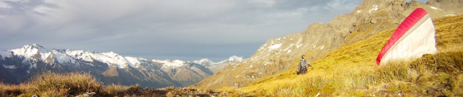
Arriving in Bishkek I saw the grandeur of the Ala Archa range as a backdrop to the dawn. A couple of days later I climbed up the dusty brown grass slope to find a launch to begin my first vol biv adventure of the trip. Travelling alone, I had some scanty information of other pilots flying here but I hadn’t even managed to get to the same launch. Being the 12th of September, it was late in the season and I was worried about two things – stable flying conditions, and cold hands.
Flying the Ala Archa behind Bishkek
Day 1
There was plenty of nerves with my first flight in the country. I wondered why I felt like this. Apart from the unfamiliarity of a new place, I think I was really worried about decking it in the hot valley with my heavy bag full of food and vol biv equipment! This wasn’t completely unfounded as I spent considerable time scratching against sunny cliffs low in the valley as I edged my way back to where the normal launch is supposed to be.
I flew past dozens of horses on a hill top without startling them. I passed a lone vulture but the vast majority of them were on the house thermal. There I climbed up but only temporarily. The inversion was around 2000 metres, high enough to realise my second fear of getting cold hands. After sinking out a little I made sure I took the next opportunity to go on glide. After a crossing I worked my way up the valley before landing after sunset and walking until I made camp at dusk at around 1950 metres altitude.

Day two, mostly walking
Day 2
The next day I had a long walk ahead of me. Thankfully there was a great little track to follow in a beautiful valley. Autumn colour, dry ground, and glimpses to high glaciers in the side valleys. I met a solo walker, a climbing guide Hungarian expat. We had a chat. He was the only person I’d meet face to face in the hills during the whole Kyrgyzstan trip. Change was in the air – it was 10 degrees warmer in Bishkek only a week before – and the shepherds were all leaving their summer yurts.
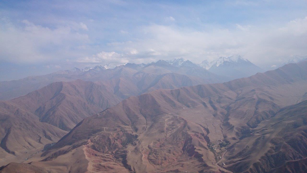
These mountains are big, and I complained about the altitude as I slogged up the valley. I was above the inversion now, and clouds built up on the peaks. I decided to launch at the lip of a small hanging valley. Not the most promising place but with a short day it was my only chance. There were thermal cycles coming and going, as well as ominous cloud cycles dropping snow on the nearby peaks. In the end I launched but may have been a bit late as I lost 170 metres, which was all I had. During the flight one of my home made hand over mitts had fallen off, I spent some fruitless time searching for it. They were fairly hopeless anyway, I lost the other one later on.


I continued walking and as soon as I reached the shadows I felt the chill of the air. I found a grassy patch by a small lake around 3000 metres and settled down for the night. I had an exped inflatable mat, my old faithful $60 synthetic sleeping bag (which I’d stuff into my polar fleece while flying), the clothes I was wearing (unfortunately my down jacket was sent to Australia!) and my paraglider in the snag bag to keep me warm. I woke with frost on my biv sac and frozen water bottles but I’d survived the night.


Day 3
The weather the next day was great. Another early start and I reached a 4000 metre pass. I only had a small dodgy section of loose rock and hard ice to negotiate before I popped onto the ridge and had my first views to the south. It was very dry country, and the valley was much higher on this side of the range. I changed some batteries as it neared midday and the first high waxy clouds started to appear. As clouds formed nearer to me I had to find a launch amongst the jagged rocky scree slopes. A patch of ice was the best option, even if it felt very lee side I managed to get in the air.
The air was exceptionally rough, even if it had been still or very light when I was sitting on the exposed divide. A westerly was ripping down the valley towards a pass, and there also seemed to be a northerly component pushing me away from my launch. I found it incredibly beautiful but very unusually I didn’t take any photos, needing to keep a close eye on my wing instead. A strong climb, a glide toward the pass, heavy sink, and scratching whilst making sure I wouldn’t get blown backwards. I supposed that this was reasonable, given the high altitudes, super dry conditions, big mountains and blazing sun. But nevertheless I thought I might try the other side of the valley.


When I was high enough to cross without worrying about the wind taking me through the pass I joined some vultures, eventually getting high above the glaciers. The vultures were sociable and took turns flying with me. I always love flying with vultures and hoped they’d follow me over the back and help me go cross country. They couldn’t be persuaded however so I was on my own again. I followed the obvious clouds, crossing back to the Ala Archa range and getting strong climbs next to a big cloud. I skirted around the edge but not without getting snowed on.
Following the range I didn’t manage to get to the next cloud, landing by a creek not far from the backbone of the range. I spent the remainder of the afternoon slogging my way up to what I thought was a launch, only to feel the wind gusting down the slope. Examining the map afterwards it seemed that the valley system funnelled winds from the north to flush the area.

Walking back up hill
Rather than climb down I pushed up loose unstable scree slopes racing against the clock. Finally after sunset I found a perfect launch, small stones and silt amongst jagged scree and broken boulders. I got ready as quick as I could and took off into the valley breeze. Around the corner a vulture showed me it was glassing off. The lift was pleasant but it was getting dark. I landed into the slope as katabatic air drifted down the mountain, and made a biv twenty metres from where I landed at 3050 metres, feeling satisfied and snacking in my grassy hollow in the dark.

Evening relaunch, day three
Day 4
Above me was icy glaciers. I negotiated the moraine to arrive at a pass. A stiff westerly was blowing and I looked for shelter while deciding what to do. With loose rocks and glaciers there weren’t any decent launching options, and anyway the wind was much too strong. I climbed the nearby peak and observed the murky clouds upwind. Descending to another pass at 3900 metres, I decided at the last minute to fly. A snow shower ahead was temporarily sheltering me from the wind.


First things first I pushed around the corner into the main valley. Then the snow came but it didn’t last that long so I tried to get up again, while eyeing the yurt in the valley. I was a little surprised that I hadn’t attracted any attention. The valley wind was quite strong and it was completely overcast so eventually I drifted back to the yurt to land. In fact there was no one inside. I dozed in the grass watching a vulture gale hang in the valley breeze.


I followed a beautiful gorge and even had a wash in the afternoon under murky skies. In the shade the wind had abated and I decided to fly. I found a place in the dead flowers to launch and suddenly there was no wind at all. I took advantage of a rogue gust and had a short flight in very strange air, a dying mix of multiple influences. I wandered further down the valley and after losing the path for an hour or so I set up camp in the grass.
Day 5

Back in lower country
The weather was beautiful again the next day but I was low on food and it was time to leave. Winding my way back to civilisation I found myself a hill to launch off. Unlike the higher mountains though it was covered in prickly shrubs and small trees, albeit only on the side I had to launch from. I got creative and found a place, needing a cycle to launch. I got above the hill but unfortunately decked it in the valley not long afterwards. Since I was now following a dirt road I was able to jag a lift with the next car into town.

Finding my last launch
A fantastic little trip with two crossings of the Ala Archa range and some acclimatisation and gear testing for the bigger mountains I planned to visit. It looked like a great day as I peered out the mini bus window but it was very dry barren country on the way to Lake Issyk Kul. I was satiated for the moment but looking forward to the next leg of the journey out of Karakol on the southern shore of Issyk Kul.

This is incredible. What a location to do it! Look forward to seeing more
Great adventure Nick!! Thanks for sharing…
Imanol
Hey man, I stumbled across your blog by googling paragliding in Svaneti. I’m a kiwi also and started flying in Bulgaria three years ago. Your blog is so inspiring! Thanks man, fly far fly safe!!
Josh
Sweet, good stuff, chances are we’ll meet one day