Late in 2006 I decided to learn to fly, but first I underwent knee surgery and during my recovery an exploratory tour of South America, always intending to return some day. Having limited information about flying there and requiring some basic Spanish the second highest mountain range in the world offers some amazing potential for adventure. In the last few months traversing the Andes from north to south I went back to the bold unsupported discovery mode I operated on here during my first visit, but with the additional depth of experience that vol biv offers between the obligatory long stints in buses. Having recently got engaged and signing up for a meteorology course next year it’s been a busy time and this trip felt somewhat like a “last hurrah”. I hope to write more about each trip (considering putting a book together soon) but here is a preview, as short as I can make it.

Another dream flight ticked off in the heart of South America
Equipment
Since I went a size down for the Red Bull X-Alps, loaded up with all my kit and food I was flying my Ozone LM5 SM 75-95kg at about 100kg. My Ozium pod harness was just big enough to cram in everything (back protection removed), with my 5L empty water bottle clipped to the outside. I decided to bring my Macpac ultralight 1.5 person tent, along with half a (foam) carry mat and a small (cheap) sleeping bag and jandals in my bum pocket, my “first aid” bits and pieces repair kit and spare clothing in the thigh pocket, and in the back pocket I packed my ozone backpack, day bag, food bag, and bivvy sack – which I’ve been using as a snag bag for the glider.
Carrying my gear my glider bag was always full and my day bag and food bag hung off my front. During the night I’d use the ozone backpack as an extra sleeping mat, along with the harness (complete with Independence reserve parachute) and glider in bivvy sack alongside for when it was colder. The tent was insurance for colder temperatures at higher altitudes, the jandals for letting the feet breath (amongst dirt and rubbish whilst travelling), and I had a few extra useful things that I’d ditch to go as light as possible – but it was a good compromise. I was always able to travel with everything meaning I had the freedom to make plans on the go.

Gear for the trip
For clothing I had my Macpac pertex trousers, a light pair of shorts, a very light tshirt which I kept clean, tending to wear my shirt every day (sun protection), under layer when it was cooler, my alpaca jersey purchased in Peru simply because I couldn’t fit it anywhere else, a thin down vest and a thicker full length down top, gloves, and overmits. I had two neck warmers, a balaclava just in case, and the obligatory lightweight raincoat, hat, and sunnies. I had one or two spare pairs of socks (very light) but actually never used them, simply washing my Bridgedale socks (one pair) whenever I had the opportunity – I have to admit these have held up rather well. My lightweight Quechua Forclaz 100 boots have performed very well (purchased in May in Bulgaria), enduring at least as much abuse as my Solomon boots which I destroyed last year (purchased in Nice in April and looking pretty rugged by the time they reached Kyrgyzstan in September) and only just starting to get holes around the flex point near the end of the trip.

Boots late in the trip (near Bariloche)
Costs and practicalities
After the rather expensive 2015 Red Bull X-Alps, in South America I returned to my roots and lived on next to nothing… I like being able to pull off great trips with minimal investment. It doesn’t always go well but if not it is character building, and since everything is new you’re always discovering something even if you don’t get to fly. One of the greatest aspects is that you tend to visit off the beaten path destinations and attract a lot of attention from the locals. It’s a good chance get an authentic look at their culture and to be forced to practice your Spanish. I always try to live like a local and now I’m used to dealing with surprised locals and tactfully avoiding their well-meaning but often misguided advice!
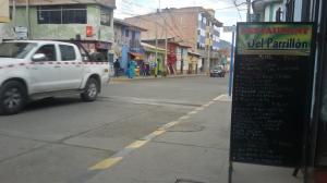
Huaraz, soup and mains (trout, rice, potato) for under $2 – offered by several restaurants, many other choices too
Colombia, Ecuador, Peru, and Bolivia are somewhat similar countries. Food is a little more expensive in Colombia, buses are around half the price (about $1/hour, talking in USD which is similar to the Euro at the moment) but old and dirty in Ecuador, accommodation is always variable, tending to be more in some cities but often under $10 for a cheap hotel room elsewhere (hostels for westerners often cost more!), wifi is generally available in hotels (remember to ask) but not in the restaurants which I like. This is because the menu el dia (typically starting at $2) is reliability good value, fast, and requires no decision making on my part. It depends how fussy you are because the soup is often full of silandro (similar to parsley), chicken feet, or other bones; the mains vary but typically include rice and limes, potatoes, and / or beans; and often a drink is included, sometimes with dessert. Look for locals and you will find them, order something different and pay three times as much (if they have it) and wait much longer.
Supermarkets tend to be expensive, and given they stock a very limited variety of imported products and I don’t have a cooker I find it difficult to find what I need (muesli, chocolate, nuts etc would be a good start, but I’m forced to improvise). There is not a lot of variety in their cuisine anyway (they just love chicken and chips), but restaurants are better and it seems they source their food locally. It definitely is much cheaper and easier to go to a local restaurant but I can’t take ten bowls of soup with me into the mountains. I do my shopping in the street markets wherever possible. Finding some protein or fat is a challenge and the most wholesome thing was usually bread and avocadoes. So I made sure I ate as much as possible in between trips (usually making myself sick in the process) and sometimes you would also be able to get a cooked feed in the hills as well.

Cartegena supermarket – pasta $5 for 500 grams? Think we’ll get dinner for two for $7 instead!
Many tourists pay three times as much for Cruz del Sur but I prefer the cheap local buses. You might be used to booking ahead but particularly in the Andean countries you are much better off just playing it by ear. You simply turn up at the bus station and walk between agencies asking their price and departure time – only once (in Santiago de Chile) I could not catch a bus (public holiday, everything sold out). Occasionally the buses may go to their own depot, which makes it difficult to connect to other buses if you are continuing to the next destination – unless of course, you are willing to deal with taxi drivers!
Crossing borders was generally pretty straight forward and fairly quick, although it pays to google your intended crossing and plan ahead a little bit. Changing money on the street is the way to go, carry as much US dollars as you’re comfortable with (in Argentina and Chile Euros are fine as well). There was some strange issue in Colombia with the ATM withdrawal rate being significantly better than the street exchange rate so we held onto our cash there. In Argentina you’ll lose about a third if you use the ATM, so google the blue market rate and plan to change money somewhere with good competition.

Bolivia has a cheap reputation but don’t post anything – my private centrally located room cost less than two stamps!
Argentina is basically European but with steadily deteriorating infrastructure and many things are dysfunctional leading to high prices. Buses cost three times as much as Chile (where you can get $15 for overnight), which is the most developed country and similar to Western Europe. Argentines shop in Chile, but Chile isn’t particularly cheap, especially if you’ve come from the north. It is nice to have more variety in the supermarkets though and to be able to buy things like chocolate. A sit down meal in Argentina will always cost more (at least double if including drinks) than a hostel including breakfast. Overall, you generally get what you pay for in terms of quality, unless of course you are paying a premium for the name or fashion etc.

In Mendoza some supermarkets cost more than in Australia – always look to the markets for a good deal
Colombia and Ecuador
My first flight in the continent was at an established site, Chicimocha canyon in Colombia. It was a pleasant flight and it was nice to look over the nearby walk we’d done in the area and socialise with the local pilots.

Walking in the Chicamocha canyon the day before flying it
The next time I got the glider out was in Los Nevados national park, high on the slopes of Tolima volcano. Before I was able to launch the cloud predictably returned after a clear morning and I was forced to walk down. The next day I tried an exit flight before we descended into the jungle, and after a very short stint in awful air (the constant wind was rolling over the valleys) I put it down in a tiny clearing, pulled my glider out of the bushes, and for the next hour got my penance “swimming” through dense jungle in the exasperatingly thin air at 3700 metres.

Paramo on Tolima volcano, eruption on Ruiz in distance
I knew that my chances of flying were better on the lower ranges but I’d rather take my chances in the bigger hills for scenery value, where you can always keep on walking if the weather is no good. Given the near constant wind and (relatively!) low cloud we’d experienced, there was a lot of walking involved. My only flight in Ecuador was after camping on the slopes of the Chimborazo volcano, waking up in the swirling cloud, deciding it was best to get off before the wind mixed in (the cloud was slowly lifting), and then being slightly surprised to manage ground speeds of over 90 kilometres per hour!
Summary:
In September during our visit there was a lot of easterly wind. At altitude, Los Nevados was mostly cloudy and wet – when it did clear, convective clouds were quick to form with the first sun. Climate is very local – in Quilatoa in Ecuador it is much drier, but certainly exposed to wind. The mountains close to Cuenca were similar – blue skies and more stable weather but very windy. I was left wondering how far south I’d have to go to escape the easterly. I also find that volcano country is not the ideal terrain for vol biv – there are often gradual slopes and big gaps between terrain features, making things difficult. Also keep in mind that around the equator you have to go very high until the vegetation thins out.

Short flight from Chimborazo slopes
Northern Peru
Tracklogs: day 1, day 3 (main flight)
Having seen Colombia and Ecuador, once Kamila left for her new job I quickly made my way down to Peru. Approaching the border on the bus I would go between Google Maps on my phone and looking out the window – there was certainly a lot of uncertainty about what would happen next, I was really throwing myself into the deep end. I stocked up on several days food, crossed the border and changed US$12 for Peruvian Soles, as I paid attention to the cloud development and afternoon breezes of the day. In the evening I kept a close eye on how much water I had because there was none at all available in the gullies beneath a sizeable mountain.

Starting out in northern Peru (near Suyo)
The next day I eventually connected with a good walking track on the ridge, and found that the clearing I’d spotted earlier on Google Earth was in fact a corn paddock. I needed a little creativity and luck to get off cleanly but managed it first time. Having arrived early but remaining conservative about my launching time I managed to climb out and then it was on. I was relieved to rack up some miles and get into the mountains where the vegetation thinned out and there were plenty of re-launch opportunities. Earlier I’d given myself a 50-50 chance of success, but I’d made myself get out there and give it a go to make sure I started out on the right foot.

Landing high for a short moment of peace
The following day I had a few flights that started out promising but put me on the deck. The air is really strong in the mountains (arid and at altitude), and if you’re not in strong lift your in strong sink. The locals are the other thing you have to contend with, it really is incredible how many school kids can materialise out of what seems like a quiet mountain village. Perhaps they are more suspicious being near the border… I was interrogated on multiple occasions, and it required a lot of patience to console them and get them onboard. They warned me of a dangerous area further to the east where locals had formed an opinion of foreigners based on the past behaviour of mining companies in the area.

Camping with the “mexican” hedge plants
My third days flying was the best of the trip, involving strong air and quickly changing fortunes just like the previous day, an appreciable wind from the east, scratching over ridges in the shade, booming thermals over high desert, more wind, and a climb to altitude where I could see the change from the jungle air and showers encroaching from the east and the Pacific air beneath where I would complete the flight over tropical vegetation.

About to dive off windy high ground into the Pacific air
On the fourth day the winds were even stronger and I could not fly, so it turns out my preconceptions of having a 50-50 chance of getting somewhere were very accurate!
I had entertained thoughts of attempting a crossing of Peru entirely by vol biv but the relentless easterly ate away at my ambitions. Reaching a sizeable town and discovering the nearest ATM was three hours’ drive away was the final straw and I took a ride out to the coast, only to realise that travel on the road is hardly a shortcut way to getting around the country – nevertheless the following day I arrived in Huaraz.


Huaraz, the Cordillera Blanca
Tracklogs: arriving in Huaraz, to Santa Cruz valley, among glaciers, along length of Cordillera Blanca, unsuccessful morning flight, to Yerupaja.
After an overnight bus I jumped in a shared taxi and left the dirty desolate dreary coast for the clear air of the mountains. Reaching a 4000 metre pass I decided it just wasn’t right to be driving downhill with the sun shining so I jumped out and took off. Despite booming cumulus towering over the dry tussock slopes of the Cordillera Negra, it took some scratching over the shallow slopes and web of power lines until I was able to cross the valley onto the glacier encrusted Cordillera Blanca. As usual in these parts the day changes quickly, so by the time I landed in Huaraz for lunch a strong reverse valley wind was blowing from the south as rainy squalls threatened.


The next day I tried my luck on a likely looking spur above Caraz, an easily reachable town further down the valley. While I was concerned about the prickles and hoped not to repeat the hot walk to launch the site worked so well that I was to return here later in the week. The sun really dominates here with clear skies, thin air, and very arid hills – even early in the morning the thermals are a force to be reckoned with. Hold on and harness the power – and it’s your ticket to saving long and tedious dusty winding roads through the mountains. During the week cloud base obscured the peaks in the afternoon, but there were still adventures to be had. In these mountains mere daylight is enough to fuel thermal activity, and the views of vegetated cliffs and high glaciers beneath the hidden peaks makes for very memorable flying.


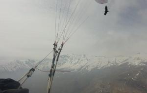
Finally the weather came good and it was back to Caraz to get boosted up to altitude. As a northerly wind strengthened, I hung in there to have an amazing flight along the front of the Cordillera Blanca, getting blown past glaciers and climbing above them to 6000 metres. After covering over 100 kilometres I landed high before the range dissolved into a high tussock plateau. I spent a night in a grass hut then puffed my way over a high pass to a morning launch. Again things looked promising but in the end I succumbed to the northerly, landing in the valley. It took a supreme effort to climb back up to a spur where I waited for a cycle (on the ground there were very obvious alternations between calm and 20 knots) before getting blasted up and crossing a couple of deep valleys before sharing the air with a condor on the northern flanks of Yerupaja in the Huayhuash. Big air and big mountains, hold on and see where the wind blows you!


Close to the Nazca lines
The scenic route to Cuzco
Tracklogs: day1 Apurimac crossing, day2 before showers, day3 salkantay machu picchu cuzco.
Inspired by my grand entry into Huaraz, I began my Cuzco trip about 100 kilometres to the west in Abancay. After an overnight bus it felt strange to be walking through a town unknown to tourism, with at least a hundred riot police in force in anticipation of the days’ planned march (they assured me everything was ok). Later that afternoon I was ecstatic as I thermalled from ridge to ridge above the town, perhaps because of the delight at success after such improbable beginnings. Crossing the enormous V-shaped Apurimac river was awe inspiring, and the winds funnelling from the jungle along with towering cumulus on the icy peaks made me happy to make a safe landing on the tussocky ridge and leave the air to the condors.


Camping on the ridge above a steep east facing slope I woke above the clouds. I was given a small late morning window once the clouds had risen up to fly up the valley and into the Salkantay before it overdeveloped. Landing next to a conveniently located tin roofed shelter I rushed for cover as the rain had just started to fall. After packing up I enjoyed a hot lunch at the nearby camp before a pleasant walk in the clouds and intermittent thundershowers to the high pass beneath the heavily glaciated Salkantay mountain, a popular alternative route to the famous Inca trail.

Salkantay 6271m just before launch
To my surprise the day dawned clear! Before sunrise on the 4800 metre pass I was up and away, delayed by changing conditions and forming cloud I finally got into the air before 9am. The sunny slopes already packed a powerful punch, and I flew to the edge of the valley for a last look before diving into the jungle. Pushing into headwind I knew I was running against the clock as the valley winds would only get stronger. Finally I reached the iconic ruins of Machu Picchu. Totally ecstatic that this long dreamt of flight was being realised, I still had a long way to go. Flying tailwind I was reaching ground speeds of over 80 kilometres per hour as I followed the Sacred valley back towards Cuzco. Higher and higher I eventually climbed to well over launch height, before landing a half hour walk from Cuzco. That flight was an experience hard to beat, although given the conditions I’m not sure I’d want to try it again!


Big air, altitude, and the altiplano
Main flight with highest ever thermal
From Cuzco I would continue following the Sacred valley to the east. The air is incredibly strong here from early hours, just like in Huaraz. I found myself landing before midday simply because it was all getting to be a bit much for me! It’s a good time of day to have a picnic. One of the picture perfect memories I have is of a Quechuan woman enjoying the views from her grassy knoll, in bright pink traditional dress with the snowy Ausengate behind, and pretending to be busy tending to her small flock of llamas once she spotted me flying past.


I flew slowly and carefully through shallow slopes in the shade before I could connect with steep rocky cliffs baking in the sun. These took me to my highest ever altitude, 6969 metres – seven metres higher than the pinnacle of the continent. It was one of those thermals you don’t really want to stay in, but don’t want to leave! Being well acclimatised I didn’t notice any adverse effects beyond being a little short of breath at times, and since the terrain is 3-5000 metres it was cold but bearable.
A beautiful cross country followed, opting not to push for the glaciers in the distance as they were surrounded by flatter ground. Rather than being defining terrain, they were just located at the boundary of the more humid jungle airmass. Instead I tended towards the highway. While the thermals were good my glides were rather pathetic in the headwind. Still I made good distance and landed on a hill close to the border of the Cuzco province. The next morning I had a beautiful flight but it was cut short in what I found to be extremely rough air. I had my first ever half riser twist during cross country flight, before landing in the valley at 10am.


More difficult conditions from Arequipa to Argentina
Tracklogs from Arequipa, Chivay (Colca canyon), Sorata (first of three flights), Coroico and Uyuni.
My next stop was Arequipa, where I found myself a launch amongst the cactus between a cement mine and processing plant. Conditions were flyable but it was difficult in the stable air. This area is extremely dry and doesn’t even have afternoon cumulus clouds for most of the year. It was an interesting diversion but flying up to the Colca canyon did not seem possible in these conditions.


Taking off from the slopes of a 5000 metre volcano near the town of Chivay, I rode the bumps with low ground clearance over the confused terrain before I could get established and into the Colca valley nearby. After an hour or so though I got fed up with the difficult conditions, dominated by stability and wind, and pulled the pin, landing by the road. Next stop Bolivia!

Sorata, Cordillera Real
I’d longed to fly the Cordillera Real since seeing it in the distance from Lake Titicaca on my first trip here. Getting myself to Sorata, conditions were not ideal – howling wind on the altiplano and having to descend to get beneath the clouds. It was flyable in the valley but somewhat pointless as the low cloud base obscured the glacier views and trapped you in the local valley. I decided to move on.
From La Paz the easiest way to access the Cordillera Real is via the road to Coroico. I disembarked at La Cumbre (4800m) in the evening to find a camp in the thick fog, but was treated to mostly clear skies (and fresh snowfall!) the following morning. I was hesitant to fly because of a potentially long walk out (there is an Inca trail which you can follow through a few villages before climbing up through the jungle and back to the road, but it takes several days). I decided that wasn’t excuse enough and took off from near 5000 metres before the cloud completely enveloped launch. A relatively short flight followed, but mostly tense moments as the focus was on landings, or lack thereof. Vast valleys dropped away beneath me, completely covered in dense tropical jungle. Threading my way over the high ridges from one high scrubby clearing to the next I was happy to finally make it to the last ridge by the road before the valley winds picked up. Relaxing for a midday picnic I observed the broody clouds slowly descend down from the mountains.


Not willing to wait and see if conditions would improve, I rolled on to the south. Clouds and instability gave way to dry stability and wind in Uyuni. I had a short flight by the famous salt flats but landed as it really was too windy and the thermals were being blown apart. After realising that ad-hoc transport to the volcanoes by the Chilean border was hard to come by, I decided to instead dedicate part of my remaining time to visiting Patagonia.

Uyuni and salt flats with volcanoes on distant Chile border
I had meant to spend some time in the mountains around Salta in northern Argentina, but I was wary of how arid it looked. Finding it hard to spend the day in the bus when the sun is shining, I disembarked at Tilcara and climbed up the hill. Stratocumulus covered the valley to the south (a cloudy microclimate, I was told later), and a strong wind arrived in the afternoon. In any case with cactus and nasty prickly plants everywhere it looked very unfriendly for pitching a tent, let alone launching a paraglider. Having no water to be found also makes it a difficult place to do vol biv – I yearned for glaciated mountains.

More arid country in Tilcara, northern Argentina
Around Aconcagua
Tracklog to Puenta del Inca.
On the long bus ride to Mendoza there was no regrets at skipping this part. Dry, sandy, arid, and shaded by stratocumulus! My next outing was near Puenta del Inca, on the highway to Santiago de Chile. In the rain shadow of the highest mountains of the Andes it is a very stark and dry country. The westerlies were certainly present during my visit. After three nights walking a nice loop through spring snows and orange rocks I managed an exit flight. Waiting for the sun I risked a mid-morning take off after a condor climbed in front of me. After a beautiful thermal with Aconcagua views I was hit by the mixing winds which I knew were there, and went to the valley to land. Half an hour afterwards the winds on the ground became very strong indeed – a dynamic place.

Morning flight with Aconcagua views
Next to Chile. The locals welcomed me in Santiago and for some reason a simple evening soar at their local site had me grinning exuberantly. It was gentle, it was easy, but it was just so fun! The next day we visited the local ski field, which has potential on a good day but with the haze and low cloud we managed to extract just a short flight, made memorable by the condors. Dozens of them flying in the area and in contrast to my previous experience these ones were social, sharing thermals and even flying right next to my wing. Amazing.
Flying with condors, Farallones ski field, Santiago
Patagonia – Cochamo Chile to Bariloche Argentina
Tracklogs: Cochamo sled ride, leaving Cochamo valley, crossing the border, to Bariloche 1, 2, 3,
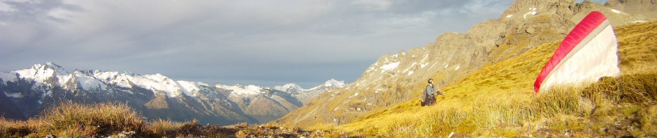
Despite all sensible recommendations to head north, my next destination was Patagonia, a place known for high rainfall and strong winds. On arrival early in the morning the weather certainly matched expectations, but during the day the overcast sky started to clear. The following day as I tramped above Cochamo the wind had died – I couldn’t believe my luck. The scenery and vegetation has a strong resemblance to Fiordland in New Zealand, with a climate to suit. After a couple of days in the area I had a sensational passage through to Bariloche in Argentina and beyond, with views a hundred kilometres in every direction over the snowy mountains, lakes, and fiords of the region. To affirm my luck it clouded up on the day I left.
")


Final thoughts
South America for me has been a place of adventure. Wind, strong conditions, high terrain, cloud cover, vegetation issues… I guess it’s a big continent and you can find everything! It has tested my abilities and it’s only the experience I’ve gained dealing with other seemingly dangerous situations in the past that has given me the confidence to attempt these flights. I’m continually impressed with the performance and safety of my wing. I did have a hard landing where I rolled my ankle and scuffed my harness, and I aggravated that again, but never to a point where I had difficulty walking. It’s generally unacceptable for me to have any injuries flying solo in remote areas, but in the poorer countries in particular there are usually people around that see you and look out for you. I’m still a little anxious sometimes when faced with the unknowns of doing something new but I find that if you take things one step at a time and don’t let your imagination get too wild or overrun with fear, it is amazing what you can do.

A quick flight from Villa la Angostura

Awesome article Nick. Pity you are getting a real job!!
Thanks mate, about the job – change is as good as a holiday!
A great read and inspirational adventure. Thanks for sharing your experiences, Grant
Lovely read & fantastic photo. I’ve gone through it a couple of times and keep coming back for more.. Looking fwd to your book(!)
Bro you are an absolute beast. I had to come back and reread this one cause it’s so good. It just blows my mind that you vol biv solo in these mountains first time. Keep it up cuz!
Thanks mate! Have been meaning to write more, this blog was just a summary!